Sagebrush

View guide.
This tool is designed to rapidly assess and manage perennial and intermittent lotic (flowing) water systems. Lentic, or still-water, systems, such as wet meadows, swales, seeps and marshes, are inherently different.
This guide is not an instruction manual but a decision-support tool for understanding how riparian areas such as creeks, rivers and streams should function. This guide helps managers determine whether a riparian area is functioning properly and how to restore or maintain proper function. A wide variety of natural resource professionals or land managers will find this guide helpful because it provides a framework for land managers to identify, discuss and address threats to riparian resources.
The goals of this tool are:
- Facilitate communication about riparian conditions across a broad audience of stakeholders.
- Provide an assessment that easily integrates with existing protocols and programs.
- Help users identify factors impacting stream resilience.
- Help users assess and prioritize areas that may require more detailed investigation.

View article.
Effective wildlife management requires robust information regarding population status, habitat requirements, and likely responses to changing resource conditions. Single-species management may inadequately conserve communities and result in undesired effects to non-target species. Thus, management can benefit from understanding habitat relationships for multiple species. Pinyon pine and juniper are expanding into sagebrush-dominated ecosystems within North America and mechanical removal of these trees is frequently conducted to restore sagebrush ecosystems and recover greater sage-grouse. However, pinyon-juniper removal effects on non-target species are poorly understood, and changing pinyon-juniper woodland dynamics, climate, and anthropogenic development may obscure conservation priorities. To better predict responses to changing resource conditions, evaluate non-target effects of pinyon-juniper removal, prioritize species for conservation, and inform species recovery within pinyon-juniper and sagebrush ecosystems, we modeled population trends and density-habitat relationships for four sagebrush-associated, four pinyon-juniper-associated, and three generalist songbird species with respect to these ecosystems. We fit hierarchical population models to point count data collected throughout the western United States from 2008 to 2020. We found regional population changes for 10 of 11 species investigated; 6 of which increased in the highest elevation region of our study. Our models indicate pinyon-juniper removal will benefit Brewer’s sparrow, green-tailed towhee, and sage thrasher densities. Conversely, we predict largest negative effects of pinyon-juniper removal for species occupying early successional pinyon-juniper woodlands: Bewick’s wren, black-throated gray warblers, gray flycatcher, and juniper titmouse. Our results highlight the importance of considering effects to non-target species before implementing large-scale habitat manipulations. Our modeling framework can help prioritize species and regions for conservation action, infer effects of management interventions and a changing environment on wildlife, and help land managers balance habitat requirements across ecosystems.
Visit conference website.
This year’s meeting will be January 28-February 1, 2024 in Sparks, NV.
View article.
Mapped representations of species−habitat relationships often underlie approaches to prioritize area-based conservation strategies to meet conservation goals for biodiversity. Generally a single surrogate species is used to inform conservation design, with the assumption that conservation actions for an appropriately selected species will confer benefits to a broader community of organisms. Emerging conservation frameworks across western North America are now relying on derived measures of intactness from remotely sensed vegetation data, wholly independent from species data. Understanding the efficacy of species-agnostic planning approaches is a critical step to ensuring the robustness of emerging conservation designs. We developed an approach to quantify ‘strength of surrogacy’, by applying prioritization algorithms to previously developed species models, and measuring their coverage provided to a broader wildlife community. We used this inference to test the relative surrogacy among a suite of species models used for conservation targeting in the endangered grasslands of the Northern Sagebrush Steppe, where careful planning can help stem the loss of private grazing lands to cultivation. In this test, we also derived a simpler surrogate of intact rangelands without species data for conservation targeting, along with a measure of combined migration representative of key areas for connectivity. Our measure of intactness vastly outperformed any species model as a surrogate for conservation, followed by that of combined migration, highlighting the efficacy of strategies that target large and intact rangeland cores for wildlife conservation and restoration efforts.
View article.
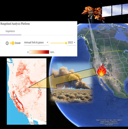
Adequate numbers of replicated, dispersed, and random samples are the basis for reliable sampling inference on resources of concern, particularly vegetation cover across large and heterogenous areas such as rangelands. Tools are needed to predict and assess data precision, specifically the sampling effort required to attain acceptable levels of precision, before and after sampling. We describe and evaluate a flexible and scalable process for assessing the sampling effort requirement for a common monitoring context (responses of rangeland vegetation cover to post-fire restoration treatments), using a custom R script called “SampleRange.” In SampleRange, vegetation cover is estimated from available digital-gridded or field data (e.g., using the satellite-derived cover from the Rangeland Assessment Platform). Next, the sampling effort required to estimate cover with 20% relative standard error (RSE) or to saturate sampling effort is determined using simulations across the environmental gradients in areas of interest to estimate the number of needed plots (“SampleRange quota”). Finally, the SampleRange quota are randomly identified for actual sampling. A 2022 full-cycle trial of SampleRange using the best available digital and prior field data for areas treated after a 2017 wildfire in sagebrush-steppe rangelands revealed that differences in the predicted compared with realized RSEs are inevitable. Future efforts to account for uncertainty in remotely sensed−based vegetative products will enhance tool utility.
View article.
The sagebrush biome is a dryland region in the western United States experiencing rapid transformations to novel ecological states. Threat-based approaches for managing anthropogenic and ecosystem threats have recently become prominent, but successfully mitigating threats depends on the ecological resilience of ecosystems. We used a spatially explicit approach for prioritizing management actions that combined a threat-based model with models of resilience to disturbance and resistance to annual grass invasion. The threat-based model assessed geographic patterns in sagebrush ecological integrity (SEI) to identify core sagebrush, growth opportunity, and other rangeland areas. The resilience and resistance model identified ecologically relevant climate and soil water availability indicators from process-based ecohydrological models. The SEI areas and resilience and resistance indicators were consistent – the resilience and resistance indicators showed generally positive relationships with the SEI areas. They also were complementary – SEI areas provided information on intact sagebrush areas and threats, while resilience and resistance provided information on responses to disturbances and management actions. The SEI index and resilience and resistance indicators provide the basis for prioritizing conservation and restoration actions and determining appropriate strategies. The difficulty and time required to conserve or restore SEI areas increase as threats increases and resilience and resistance decrease.

What: USGS will host 7 webinars focusing on updates to sagebrush and fire related research funded in FY23. Each webinar will loosely follow the themes of Fire, Invasives, Sagebrush Restoration, Climate, and Grouse/Wildlife. More information on the projects covered will be shared soon.
When: Thursdays from 8:00-10:30 PST/9:00-11:30 MST
Still upcoming is: Feb 29Recordings: Webinars will be recorded, but it will be some time before they will be available to a non-DOI audience.
How: Microsoft Teams meeting (no registration required)
Meeting ID: 270 206 584 228Passcode: zdGDqX
FEB 29 Presentations:
TBA

Webinar registration.
The sagebrush biome is one of the largest habitat types in North America, spanning 175 million acres and home to sage grouse and 350 other species. USDA’s Natural Resources Conservation Service (NRCS) launched the Sage Grouse Initiative in 2010 to deliver win-win voluntary conservation solutions that support ranchers and other landowners in improving the productivity of their working lands while benefiting sage grouse. The Initiative has successfully addressed key threats impacting sage grouse by focusing on population core areas. Science has helped strategically guide, refine, and inform these voluntary, private lands conservation efforts across 11 western states.
Webinar recording.
Cara Applestein, Samuel “Jake” Price, and Matt Germino, USGS, present their latest work on accuracy assessments of the newest mapped products for burned areas. They will give guidelines for reliable application, including stating what is “unsafe” application, what the scientific basis for the guidelines are, and examples of how they use the data. They will address RAP, RCMAP, and LandCart.

Summit webpage.
The summit will be in Lakeview, OR on Sept. 26-27, 2023. There will be in-person and virtual options.