Fire Behavior

View article.
Focus on wind changes and mid-tropospheric properties may be counterproductive or distracting when one is concerned about major growth events on very large fires.
View article.
Our study found that fire perimeter source and fireline buffer width had the largest impact on quantified fireline effectiveness metrics. Misclassification of firelines produced dramatic erroneous results which artificially increased the effectiveness and decreased suppression effort. High-severity fires were shown to be less effective across all fireline types and required higher suppression than most low- and moderate-severity fires.

View article.
This review summarises a growing body of evidence indicating that greater use of in situ, remotely sensed, and modelled soil moisture information in fire danger rating systems could lead to better estimates of dynamic live and dead herbaceous fuel loads, more accurate live and dead fuel moisture predictions, earlier warning of wildfire danger, and better forecasts of wildfire occurrence and size. Potential uses of soil moisture information in existing wildfire danger rating systems include (1) as a supplement or replacement for drought indices, (2) for live and (3) dead fuel moisture modelling, (4) for estimating herbaceous fuel curing, and (5) for estimating fuel loads. We identify key remaining research questions and note the logistical challenge of convincing wildfire professionals of the importance of soil moisture compared with more familiar wildfire danger metrics. While obstacles remain, the path forward is clear. Soil moisture information can and should be used to improve fire danger rating systems and contribute to more effective fire management for the protection of communities and ecosystems worldwide.
View story map.
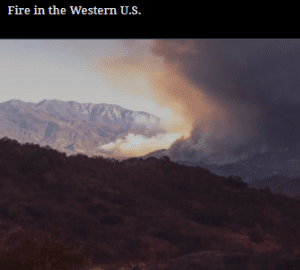
But over the past few decades, wildfires have worsened by almost every metric. It’s impossible to ignore this new consequence of environmental change. Fires are getting larger, more severe, more destructive and dangerous, and eliminating entire patches of forests, grasslands, and shrublands.
The combination of changing climate, extreme weather, land use, aggressive fire suppression policies, and wildland urban interface expansion have contributed to altered fire behavior regimes. And all of these past and current factors are converging in a big way in the western U.S. Today’s megafires pose an increasing threat to human health, infrastructure, natural resources, and ecosystem resilience.
View synthesis.
Here, we synthesized literature and conducted a survey of forest and fire managers to assess current understanding of how fire interacts with aspen stands, as well as to examine possible factors that influence fire occurrence, behavior, and severity in aspen communities. We found evidence that the presence of aspen reduces fire occurrence, fire behavior, and fire severity, but this effect is dependent on many factors, including the percentage of aspen vs conifers in the overstory, load and type of understory fuels, weather, and season. We did not find any quantitative management guidelines on how to create, maintain, or use aspen stands to reduce fire risk. The large gap between “common knowledge” and empirical evidence regarding aspen’s ability to inhibit fire requires further research.

Webinar recording.
The fourth webinar of the Forest Service’s Research and Development SCIENCEx FIRE week.
Modeling Risks and Tradeoffs
Wildland Fire Behavior and Ignition | Greg Dillon
Juggling Risks and Tradeoffs Toward a More Resilient Future: The Known, Unknown, Unknowable, and Unpleasant | Pat Manley & Nick Povak
Southern Forest Outlook: Fire in a Changing Landscape | Nick Gould
Webinar recording.
The third webinar of the Forest Service’s Research and Development SCIENCEx FIRE week.
Fire Behavior
Wildland Fire Behavior and Ignition | Sara McAllister
3D Time-Dependent Fire Behavior Models: What They Do and the Need for Observational Datasets | Ruddy Mell
Fire Behavior Assessment Team (FBAT) and Wildfire Monitoring | Matt Dickinson

Conference website.
Better wildland fire governance is needed to protect biodiversity, foster carbon sequestration and healthy forests and assure they are providing goods and services that do not vanish in wildfire smoke.
As Chairman and on behalf of the Organizing Committee of the 8th International Wildland Fire Conference we invite you to come to Portugal with your knowledge, insights, and thoughts. We welcome you to contribute with your institutional or professional case study, your scientific work or your operational success or failure in tackling complexity and uncertainty when governing or managing wildfire risk.
At Porto, you will have a lifetime influencing professional experience, through the opportunity to meet with thousands of people coming from all over the world. We all share similar problems and are deeply committed to work on the solutions.
We will be honored to host you at Porto, to discuss and participate in defining Governance principles towards the development an international framework. We believe that your piece of the puzzle will matter to help your nation and all nations to be better prepared to deal with the challenges ahead of us and to build fire-resilient landscape and societies.
TIAGO MARTINS DE OLIVEIRA
Chairman of the AGIF Board of Directors
View story map.
On a dry winter morning between Christmas and New Year’s Eve 2021, the communities in Boulder County braced for the wind. The area lies at the base of the Front Range, made up of flat-topped mesas and open grasslands where creek bottoms are lined with cottonwood trees. On the outskirts of the communities are scattered homes and ranchettes. Farther east are established neighborhoods with mature landscaping and newer subdivisions sparsely planted with shrubs and ornamental hardwoods. Green corridors and trails run through the area.
Webinar recording.
This presentation discusses the results of 17 years of active fire data from Moderate Resolution Imaging Spectroradiometer (MODIS) to characterize the daytime and nighttime dynamics of wildfires across the continental US. Whereas daytime fire activity was widely detected regardless of fire type, nighttime fire activity was mainly detected inside wildfires and particularly within large wildfires in the western US. The analysis also found that as fuels dry, there is an increase in larger and more intense wildfires with higher chances that fire activity will persist overnight. Results indicate that increasing trends in nighttime wildfire activity have coincided with increasing wildfire sizes. Nighttime fire activity already poses additional risks to firefighters and communities, and this presentation discussed the probability that projected increases in the frequency of large wildfires will be accompanied by increases in the extent and intensity of nighttime fire activity.