Fire History

View story map.
This story map accompanies the publication (Strand et al. 2025) and describes how anthropogenic and naturally occurring events have shaped the region. We looked at how and where fires occurred in the past and compared that to more contemporary fire records. These findings provide guidance for natural resource professionals looking for the best available science to inform their management.
View article.
View story map.
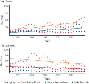
This study estimates how fire regimes have changed in the major Great Basin vegetation types over the past 60 years with comparisons to historical (pre-1900) fire regimes. We explore potential drivers of fire regime changes using existing spatial data and analysis. Across vegetation types, wildfires were larger and more frequent in the contemporary period (1991–2020) than in the recent past (1961–1990). Contemporary fires were more frequent than historical in two of three ecoregions for the most widespread vegetation type, basin and Wyoming big sagebrush. Increases in fire frequency also occurred in saltbush, greasewood, and blackbrush shrublands, although current fire return intervals remain on the order of centuries. Persistent juniper and pinyon pine woodlands burned more frequently in contemporary times than in historical times. Fire frequency was relatively unchanged in mixed dwarf sagebrush shrublands, suggesting they remain fuel-limited. Results suggest that quaking aspen woodlands may be burning less frequently now than historically, but more frequently in the contemporary period than in the recent past. We found that increased fire occurrence in the Great Basin is associated with increased abundance and extent of nonnative annual grasses and areas with high concentrations of anthropogenic ignitions. Findings support the need for continuing efforts to reduce fire occurrences in Great Basin plant communities experiencing excess fire and to implement treatments in communities experiencing fire deficits. Results underscore the importance of anthropogenic ignitions and discuss more targeted education and prevention efforts. Knowledge about signals of fire regime changes across the region can support effective deployment of resources to protect or restore plant communities and human values.

View article.
The most destructive and deadly wildfires in US history were also fast. Using satellite data, we analyzed the daily growth rates of more than 60,000 fires from 2001 to 2020 across the contiguous US. Nearly half of the ecoregions experienced destructive fast fires that grew more than 1620 hectares in 1 day. These fires accounted for 78% of structures destroyed and 61% of suppression costs($18.9 billion). From 2001 to 2020, the average peak daily growth rate for these fires more than doubled (+249% relative to 2001) in the Western US. Nearly 3 million structures were within 4 kilometers of a fast fire during this period across the US. Given recent devastating wildfires, understanding fast fires is crucial for improving firefighting strategies and community preparedness

View webinar recording.
On August 5, 1949, a fire was spotted at Mann Gulch, near Helena, Montana. The U.S. Forest Service dispatched a team of 15 smokejumpers, who were met by a fire guard from a nearby campground. When the fire blew up, thirteen firefighters were killed, three escaped. While the Forest Service studied what happened and revised its training and safety measures, few outside the agency remembered the tragedy. That is not until Norman Maclean published a meditation on it, entitled Young Men and Fire, did the event connect with national and cultural interests—and continues to thirty years later.
Fire historian Stephen Pyne and host Jamie Lewis discussed the fire on its 75th anniversary and how Maclean’s book has affected the American fire community.
Webinar recording.
The Oregon State University Extension Fire Program would like to take you on a journey of fire throughout Oregon. In this webinar, a team of regional fire specialists share diverse stories about how fire has shaped Oregon landscapes historically and currently. Understanding fire’s role in the place you live can help you become better prepared for fire and smoke, and more aware of your local ecological setting.
Webinar recording.
FRID statistics have been used for decades to help managers and scientists understand the ecological consequences of changing fire frequencies. The Forest Service Region 5 Ecology Program worked with UC-Davis to build a spatial FRID data layer that compiles information about fire return intervals for major vegetation types on the 18 National Forests in California and adjacent land jurisdictions. This data layer includes comparisons between pre-Euroamerican settlement (“pre-EAS”) and contemporary fire return intervals (FRIs). The FRID layer may be used for land and resource planning and assessment, as well as other natural resource applications such as fuels treatment planning, postfire restoration project design, management response to fire, assessing the effects of fire and fire regime change on ecosystems, and general ecological understanding of the historic and current occurrence of fire on the California National Forests and neighboring jurisdictions. This presentation focuses on the guts of the FRID data and the departure metrics, describes how to properly use the dataset, discusses some important caveats, outlines current updating and improvement work we are doing with the dataset, and describes a current national effort to develop a similar dataset and metrics for the US.
View brief.
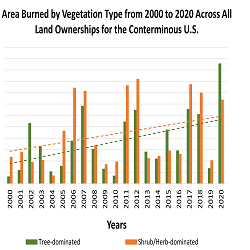
Wildfires burned more area on non-forested lands than forested lands over the past 20 years. This was true for all land ownerships in CONUS and the western US. Burned area increased over the 20-year time period for both non-forest and forest. Across CONUS, annual area burned was higher on non-forest than forests for 14 of the past 21 years (Fig. 1), and total area burned was almost 3,000,000 ha more in non-forest than in forest. For the western US, total burned area was almost 1,500,000 ha more in non-forest than in forest. From a federal agency perspective, approximately 74% of the burned area on Department of the Interior (DOI) lands occurred in non-forest and 78% of the burned area on US Forest Service (FS) lands occurred in the forest.
View article.
We use a unique dataset derived from contemporary (∼2016) remeasurement of 440 historical quadrats (∼4m2) in the central Sierra Nevada, California, in which overstory trees, tree regeneration, and microsite conditions were measured and mapped both before and after logging in 1928–1929. Pine relative abundance changed little with logging and declined to 5% of the contemporary regeneration layer. In contrast, the relative abundance of incense-cedar regeneration (32%) already outpaced its representation in the overstory (17% by basal area) before logging and proceeded to dominate the contemporary understory (49%). We did not find strong evidence for the positive influence of gaps on pine regeneration in any time period. However, across species, post-logging skid trails were positively associated with regeneration and woody debris was negatively associated with regeneration in at least one time period. We discovered that the occurrence of advance regeneration (regeneration that preceded and survived logging) best predicted new contemporary trees across all species. For shade-tolerant species, post-logging regeneration that established up to ten years after logging was also associated with new contemporary trees. In contrast, the few pine that transitioned into the contemporary canopy during the study period all established prior to logging. Our work provides evidence that low pine abundance in the regeneration layer as early as 1928 contributed to low rates of pine in the overstory in 2016, showcasing that the decline of pine likely began before logging and official federal fire suppression policies. We suggest that fire exclusion before logging perpetuated shifts towards shade-tolerant and fire-intolerant species in the regeneration layer that were early and lasting.

Webinar join link.
Presenter: Douglas J. Shinneman, Research Ecologist, USGS Forest and Rangeland Ecosystem Science Center
Description: Accurately assessing recent and historical wildfire activity is critical for numerous agencies who manage fire-prone landscapes. The Wildland Fire Trends Tool (WFTT) is a data visualization and analysis tool that calculates and displays wildfire trends and patterns for the western U.S. based on user-selected regions of interest, time periods, and ecosystem types. For instance, users can determine whether the area burned by wildfire is increasing or decreasing over time for a specific ecoregion or for land ownership types of interest. The tool is available via a web application and generates a variety of maps, graphs, and tabular data that provide useful information for fire science and management objectives, as well as for the interested public.