Monitoring

Access training videos.
This virtual- and field-based training was developed and hosted by the Oak Woodlands & Forests Fire Consortium, Lake States Fire Science Consortium, and the Huron-Manistee National Forests. The virtual event was held June 1-4, 2021, and introduced participants to:
- tools for selecting metrics that match management/restoration objectives;
- developing site-specific protocols for sampling;
- developing a monitoring handbook and monitoring protocols/program for your local ecosystems;
- how to establish long-term monitoring and quantitative/qualitative data for wildfire risk assessment;
- evaluating the need for prescribed burns and other fuels treatments.

Webinar recording.
The Center for Ecosystem Climate Solutions (CECS), with support from California’s Strategic Growth Council (SGC), built a data cube of California forest conditions for 1985 to 2023. These data include state-wide, 30-m information on ecosystem disturbance, carbon, water, and fire hazard. These data are being tested against field observations with support from CALFIRE, and an updated 2024 dataset is nearing release. This presentation will introduce the data cube and use it to quantify recent changes in California’s wildlands.
Mike Goulden is a Professor of Earth System Science (ESS) at UC Irvine. Goulden’s research focuses on Ecosystem ecology, and the Biological, physical, and chemical controls on terrestrial carbon and water cycling. Goulden has conducted extensive fieldwork on carbon exchange in tropical, boreal and temperate ecosystems. Goulden’s more recent work emphasizes satellite-based mapping of ecosystem conditions and function.
The Forest Health Research Program is part of California Climate Investments, a statewide initiative that puts billions of Cap-and-Trade dollars to work reducing greenhouse gas emissions, strengthening the economy, and improving public health and the environment — particularly in disadvantaged communities.
Webinar registration.
Human activities and natural processes have significantly altered the water resources of the United States, and continual changes are expected. This webinar will review results from the Water Resources Chapter of the 2020 RPA Assessment, summarizing recent trends and future projections of freshwater use and supply, as well as likelihood of water shortages to 2070 based on RPA scenarios and how those shortages impact communities throughout the United States. To highlight the value of the RPA approaches, we will then hear how The Pew Charitable Trusts uses information and outputs like those from the RPA project to better understand how their conservation work may affect local communities, what that means for how they engage in partnerships with those communities, and how that may translate to project objectives and metrics for success.
Webinar registration.
Human activities and natural processes have significantly altered the rangeland resources of the United States, and continual changes are expected. This webinar will review results from the Rangeland Resources Chapter of the 2020 RPA Assessment, presenting recent trends in rangeland extent, health, vegetation ground cover, aboveground net primary productivity, and livestock numbers, as well as projections of future changes in rangeland phenology, vegetation productivity, and land use. To highlight the value of the RPA approaches, we will then hear about how managers are using these assessments and data to evaluate stocking rates, update Forest Plan Revisions, and identify unhealthy trends such as loss or perennial grasses or conifer encroachment.
Webinar recording.
Learn about new geospatial data products to support wildfire planning and response including national fuel treatments, fire response districts and communities mapping.

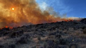
Reliability of satellite-based vegetation maps for planning wildfire-fuel treatments in shrub steppe
View article.
We compared commonly used, publicly available vegetation cover and fuels maps, specifically the Rangeland Analysis Platform (RAP) and LANDFIRE, with field-based assessments at two U.S. National Parks dominated by sagebrush steppe: City of Rocks National Reserve and Craters of the Moon National Monument and Preserve. Plant-community composition and fuels measured at ∼1700 field locations spanning ∼300,000 ha revealed that 1) RAP generally underestimated each vegetation cover type where the cover was actually abundant, and conversely overestimated cover types where they were actually scarce, and 2) there was considerable disagreement in fuel-bed maps derived from LANDFIRE compared to field observations. As a result, there were substantial discrepancies in the spatial patterning of wildfire behavior estimated from the fire-spread model FLAMMAP when parameterized with LANDFIRE compared to field-based fuel-bed maps created from Random Forests models. Reliable maps of vegetation cover and fuel conditions are needed to help guide fuels and invasive species management, especially given recent increases in pre- and post-fire treatments in arid and semiarid landscapes. The costs associated with poorly informed fuel reduction may greatly exceed the costs of field-based vegetation and fuels inventory to inform effective design of vegetative fuels treatments.
Webinar registration.
Speaker: Daryn Dockter, LANDFIRE Technical Lead, TSSC, EROS

Webinar join link.
The NRI program collects and produces scientifically credible information on the status, condition, and trends of land, soil, water, and related natural resources on the nation’s non-federal lands. It is the largest field-based survey of natural resources in the world. Inventories of natural resources have been conducted for over 65 years on non-Federal lands. For rangelands, the 12 current inventory and assessment protocols were developed in a collaboration of federal agencies, were tested for several years across the continental United States, and were set in 2004. The same set of protocols was applied to Federal rangelands beginning in 2009. This presentation describes the protocols and some of the new relevant information being generated by this longitudinal statistical study of on-site rangeland inventory.
View article.
The rate of change in invasive annual grass cover describes the trajectory of invasion. This information can be used to fine-tune priority locations and strategies for invasive species treatments. We identified locations with positive, neutral, negative, and variable rates of change. Although rates of change have accelerated, there were many locations with a consistent neutral rate of change in cover. High positive rates of change frequently preceded high invasive annual grass cover, and locations that had low cover rarely had a history of high positive rates of change. We identified potential management opportunities by combining rates of change in cover and percent cover data, illustrating both invasion severity and trajectory. We applied these potential opportunities to a map of the sagebrush biome using example thresholds. This map identifies locations that could be prioritized for different management goals and shows how those areas align with the Sagebrush Conservation Design management