Fire Behavior

View article.
Using random forest modeling and Shapley local importance measures, we found that weather and fuels were both dominant drivers of fire severity, and past fuel treatments were successful at reducing severity—even during extreme fire progression days. First-entry fires were more typically driven by top-down climate and weather variables, while for reburns (i.e., overlapping fire footprints within the period of record), severity was largely mitigated by reduced fuels and a positive influence of topography (e.g., burning downslope). Likewise, reburns overall exhibited lower fire severity than first entry fires, suggesting strong negative feedbacks associated with past fire footprints. The normalized difference moisture index (NDMI)—an indicator of live fuel loading and moisture levels—was a leading predictor of fire severity for both first-entry fires and reburns. NDMI values < 0 (i.e., low biomass) were associated with reduced fire severity, while values > 0.25 (i.e., high biomass) were associated with increased severity. Forest management was effective across a variety of conditions, especially under low to moderate wind speeds (< 17 m·s−1), and where canopy base heights were ≥ 1.3 m.
View article.
Through interviews with wildland fire and forest managers (e.g., Incident Commanders, Agency Administrators, Fire Management Officers, and Fuels Planners) on seven western wildfire incidents during 2020 and 2021, we investigated how forest fuel treatments were utilized during firefighting. We found that treatments were considered and used during incidents in various ways, including to conduct burnouts, for direct modification of fire behavior, as access points for firefighters or equipment, or as components of contingency plans. Most interviewees said treatments provided additional options and flexibility in decision-making, enhancing both firefighter and community safety. For instance, treatments were used to reduce overhead hazards to firefighters and, in some cases, were prepared to serve as safety zones.
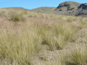
Reliability of satellite-based vegetation maps for planning wildfire-fuel treatments in shrub steppe
View article.
We compared commonly used, publicly available vegetation cover and fuels maps, specifically the Rangeland Analysis Platform (RAP) and LANDFIRE, with field-based assessments at two U.S. National Parks dominated by sagebrush steppe: City of Rocks National Reserve and Craters of the Moon National Monument and Preserve. Plant-community composition and fuels measured at ∼1700 field locations spanning ∼300,000 ha revealed that 1) RAP generally underestimated each vegetation cover type where the cover was actually abundant, and conversely overestimated cover types where they were actually scarce, and 2) there was considerable disagreement in fuel-bed maps derived from LANDFIRE compared to field observations. As a result, there were substantial discrepancies in the spatial patterning of wildfire behavior estimated from the fire-spread model FLAMMAP when parameterized with LANDFIRE compared to field-based fuel-bed maps created from Random Forests models. Reliable maps of vegetation cover and fuel conditions are needed to help guide fuels and invasive species management, especially given recent increases in pre- and post-fire treatments in arid and semiarid landscapes. The costs associated with poorly informed fuel reduction may greatly exceed the costs of field-based vegetation and fuels inventory to inform effective design of vegetative fuels treatments.

Webinar details and join link.
Wildfires are becoming more destructive as burned area increases and as more homes are built in the wildland-urban interface, but it is unclear how these patterns are affected by changing wildfire behavior in different fuel types. To better understand changing patterns of wildfire destruction, we mapped buildings exposed to and destroyed by wildfires in the conterminous U.S. from 2000-2020. From these maps, we determined that the probability of an exposed building being destroyed by wildfire has more than tripled over the past two decades, and that more wildfire destruction is occurring in forests relative to grass and shrublands. Understanding these changing patterns can help us design more effective strategies to mitigate risk.
Webinar registration.
Behave7 has just been released! We will discuss how Behave v7 differs from BehavePlus v6 by highlighting the Surface, Surface/Crown, Surface/Mortality, and Surface/Contain modules and enhancements that will be included in the next few releases in 2025-2026. This webinar will be useful for both burn bosses and RX-300 cadres.
View article.
To assess relationships between fire spread rates and landscape burn severity patterns, we used satellite fire detections to create day-of-burning maps for 623 fires comprising 4267 single-day events within forested ecoregions of the southwestern United States. We related satellite-measured burn severity and a suite of high-severity patch metrics to daily area burned. Extreme fire spread events (defined here as burning > 4900 ha/day) exhibited higher mean burn severity, a greater proportion of area burned severely, and increased like adjacencies between high-severity pixels. Furthermore, increasing daily area burned also resulted in greater distances within high-severity patches to live tree seed sources. High-severity patch size and total high-severity core area were substantially higher for fires containing one or more extreme spread events than for fires without an extreme event. Larger and more homogenous high-severity patches produced during extreme events can limit tree regeneration and set the stage for protracted forest conversion. These landscape outcomes are expected to be magnified under future climate scenarios, accelerating fire-driven forest loss and long-term ecological change.

Webinar registration.
This webinar will discuss how Behave v7 differs from BehavePlus v6 by highlighting the Surface and Surface/Crown modules and enhancements that will be included in the next few releases in 2025-2026. This webinar will be most useful for fire analysts, S-390 cadres, and S-490 cadres.
View guide. (Click on the word “guide” to view it.)
A photo guide for use in classifying fire behavior fuel models from the Scott and Burgan (2005) library that are common to the sagebrush steppe of the American west. The goal of this guide is to enable the quick and easy classification of fuel models in sagebrush steppe to –
- enhance the mapping of fuel beds in an increasingly fire prone region,
- guide the evaluation of fuel and post-fire restoration treatments, and
- improve our understanding of fuel conditions during times of the year when wildfire preparedness is greatest (i.e. hot and dry).

View synthesis.
Fire is an integral component of many Southwest ecosystems; however, fire regimes across the region have been affected by climate change, creating conditions to which these ecosystems have not adapted. Since 1980, fire frequency, size and severity have increased in many ecosystems in the western US due to changes in climate combined with a history of fire suppression and other forest management practices, such as grazing and logging…
…The goal of this synthesis is to provide a summary of the literature, published in 2023, on fire and fire-related topics
View article.
We find that significant precursors for fire suppression resource deployment are location, fire weather, canopy cover, Wildland–Urban Interface category, and history of past fire. These results align partially with, but are distinct from, results of earlier research modelling expenditures related to suppression which include precursors such as total burned area which become observable only after an incident.