Fire Regimes
View synthesis.
This review explores Integrated Fire Management as both an adaptation and mitigation strategy for altered fire regimes. It provides an overview of the progress and challenges associated with implementing Integrated Fire Management across different regions worldwide. The review also proposes five core objectives and outlines a roadmap of incremental steps for advancing Integrated Fire Management as a strategy to adapt to ongoing and future changes in fire regimes, thereby maximizing its potential to benefit both people and nature.
View story map.
This story map accompanies the publication (Strand et al. 2025) and describes how anthropogenic and naturally occurring events have shaped the region. We looked at how and where fires occurred in the past and compared that to more contemporary fire records. These findings provide guidance for natural resource professionals looking for the best available science to inform their management.
View article.
Rapid increases in wildfire area burned across North American forests pose novel challenges for managers and society. Increasing area burned raises questions about whether, and to what degree, contemporary fire regimes (1984–2022) are still departed from historical fire regimes (pre-1880). We use the North American tree-ring fire-scar network (NAFSN), a multi-century record comprising >1800 fire-scar sites spanning diverse forest types, and contemporary fire perimeters to ask whether there is a contemporary fire surplus or fire deficit, and whether recent fire years are unprecedented relative to historical fire regimes. Our results indicate, despite increasing area burned in recent decades, that a widespread fire deficit persists across a range of forest types and recent years with exceptionally high area burned are not unprecedented when considering the multi-century perspective offered by fire-scarred trees. For example, ‘record’ contemporary fire years such as 2020 burned 6% of NAFSN sites—the historical average—well below the historical maximum of 29% sites that burned in 1748. Although contemporary fire extent is not unprecedented across many North American forests, there is abundant evidence that unprecedented contemporary fire severity is driving forest loss in many ecosystems and adversely impacting human lives, infrastructure, and water supplies.
View article.
View story map.
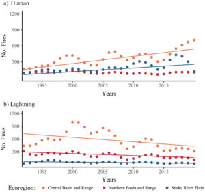
This study estimates how fire regimes have changed in the major Great Basin vegetation types over the past 60 years with comparisons to historical (pre-1900) fire regimes. We explore potential drivers of fire regime changes using existing spatial data and analysis. Across vegetation types, wildfires were larger and more frequent in the contemporary period (1991–2020) than in the recent past (1961–1990). Contemporary fires were more frequent than historical in two of three ecoregions for the most widespread vegetation type, basin and Wyoming big sagebrush. Increases in fire frequency also occurred in saltbush, greasewood, and blackbrush shrublands, although current fire return intervals remain on the order of centuries. Persistent juniper and pinyon pine woodlands burned more frequently in contemporary times than in historical times. Fire frequency was relatively unchanged in mixed dwarf sagebrush shrublands, suggesting they remain fuel-limited. Results suggest that quaking aspen woodlands may be burning less frequently now than historically, but more frequently in the contemporary period than in the recent past. We found that increased fire occurrence in the Great Basin is associated with increased abundance and extent of nonnative annual grasses and areas with high concentrations of anthropogenic ignitions. Findings support the need for continuing efforts to reduce fire occurrences in Great Basin plant communities experiencing excess fire and to implement treatments in communities experiencing fire deficits. Results underscore the importance of anthropogenic ignitions and discuss more targeted education and prevention efforts. Knowledge about signals of fire regime changes across the region can support effective deployment of resources to protect or restore plant communities and human values.
View article.
The most destructive and deadly wildfires in US history were also fast. Using satellite data, we analyzed the daily growth rates of more than 60,000 fires from 2001 to 2020 across the contiguous US. Nearly half of the ecoregions experienced destructive fast fires that grew more than 1620 hectares in 1 day. These fires accounted for 78% of structures destroyed and 61% of suppression costs($18.9 billion). From 2001 to 2020, the average peak daily growth rate for these fires more than doubled (+249% relative to 2001) in the Western US. Nearly 3 million structures were within 4 kilometers of a fast fire during this period across the US. Given recent devastating wildfires, understanding fast fires is crucial for improving firefighting strategies and community preparedness
Meeting website.
Save the date for the 2025 SRM Annual Meeting in Spokane, WA.
February 9-13, 2025
View synthesis.
Fire is an integral component of many Southwest ecosystems; however, fire regimes across the region have been affected by climate change, creating conditions to which these ecosystems have not adapted. Since 1980, fire frequency, size and severity have increased in many ecosystems in the western US due to changes in climate combined with a history of fire suppression and other forest management practices, such as grazing and logging…
…The goal of this synthesis is to provide a summary of the literature, published in 2023, on fire and fire-related topics
View article.
Climate change is altering fire regimes and post-fire conditions, contributing to relatively rapid transformation of landscapes across the western US. Studies are increasingly documenting post-fire vegetation transitions, particularly from forest to non-forest conditions or from sagebrush to invasive annual grasses. The prevalence of climate-driven, post-fire vegetation transitions is likely to increase in the future with major impacts on social–ecological systems. However, research and management communities have only recently focused attention on this emerging climate risk, and many knowledge gaps remain. We identify three key needs for advancing the management of post-fire vegetation transitions, including centering Indigenous communities in collaborative management of fire-prone ecosystems, developing decision-relevant science to inform pre-and post-fire management, and supporting adaptive management through improved monitoring and information-sharing across geographic and organizational boundaries. We highlight promising examples that are helping to transform the perception and management of post-fire vegetation transitions.
Webinar recording.
We conducted a natural range of variation (NRV) assessment of montane conifer forests in the Transverse and Peninsular Mountain Ranges of southern California. Using current and historical literature and data, we present a quantitative analysis of forest function, structure, composition, and ecological processes prior to Euro-American settlement and compare those elements to the forests of today. We highlight how grazing, logging and fire suppression have altered natural fire regimes and examine how departure from NRV conditions may inform forest management in the era of climate change.


