Fire Regimes

View article.
Frequent and catastrophic wildfires are an increasing threat to the ecological and economic stability of Great Basin rangelands, specifically sagebrush rangelands at risk of exotic annual grass invasion (Crist et al. this issue). Historically, fires were a periodic disturbance in these communities that shifted dominance from woody vegetation to herbaceous vegetation (Wright and Bailey 1982; Miller and Rose 1999) and likely promoted diversity (Davies and Bates 2020). Alterations in fuel characteristics with exotic plant invasions and increased anthropogenic ignitions have greatly elevated the likelihood of wildfires in many of these rangelands (Balch et al. 2013; Fusco et al. 2022). However, other rangelands are experiencing decreased fire frequency, largely caused by reduced fine fuels from anthropogenic-induced alterations to plant community composition or land use. Though longer fire return intervals can also be problematic because they cause undesirable plant community compositional shifts and decreased heterogeneity in some rangelands, this special issue is focused on the problem of more frequent and catastrophic wildfires as this is a more pressing concern in terms of the rate of undesirable ecosystem change and risk to property and life.
View synthesis.
Increases in fire activity and changes in fire regimes have been documented in recent decades across the western United States. Climate change is expected to continue to exacerbate impacts to forested ecosystems by increasing the frequency, size, and severity of wildfires across the western United States (US). Warming temperatures and shifting precipitation patterns are altering western landscapes and making them more susceptible to high-severity fire. Increases in large patches of high-severity fire can result in significant impacts to landscape processes and ecosystem function and changes to vegetation structure and composition. In this synthesis, we examine the predicted climatic influence on fire regimes and discuss the impacts on fire severity, vegetation dynamics, and the interactions between fire, vegetation, and climate. We describe predicted changes, impacts, and risks related to fire with climate change and discuss how management options may mitigate some impacts of predicted fire severity, and moderate some impacts to forests, carbon, and vegetation changes post fire.
View article.
Pyrodiversity may affect biodiversity by diversifying available ecological niches, stabilizing community networks and/or supporting diverse species pools available for post-fire colonization. Further, pyrodiversity’s effects on biodiversity vary across different spatial, temporal and organismal scales depending on the mobility and other life history traits of the organisms in question and
may be mediated by regional eco-evolutionary factors such as historical fire regimes. Developing a generalizable understanding of pyrodiversity effects on biodiversity has been challenging, in part because pyrodiversity can be quantified in various ways.
View article.
Sagebrush ecosystems of western North America are experiencing widespread loss and degradation by invasive annual grasses. Positive feedbacks between fire and annual grasses are often invoked to explain the rapid pace of these changes, yet annual grasses also appear capable of achieving dominance among vegetation communities that have not burned for many decades. Using a dynamic, remotely sensed vegetation dataset in tandem with remotely sensed fire perimeter and burn severity datasets, we examine the role of fire in transitions to and persistence of annual grass dominance in the U.S. Great Basin over the past 3 decades. Although annual grasses and wildfire are so tightly associated that one is rarely mentioned without the other, our findings reveal surprisingly widespread transformation of sagebrush ecosystems by invasive annual grasses in the absence of fire. These findings are discussed in the context of strategic management; we argue a pivot from predominantly reactive management (e.g., aggressive fire suppression and post-fire restoration in heavily-infested areas) to more proactive management (e.g., enhancing resistance and managing propagule pressure in minimally-invaded areas) is urgently needed to halt the loss of Great Basin sagebrush ecosystems.
View article.
We found strong support for top-down and bottom-up spatial and temporal controls on fire patterns. Fire weather was a main driver of large fire occurrence, but area burned was moderated by ignition frequencies and by areas of limited fuels and fuel contagion (i.e., fire fences). Landscapes comprised of >40% area in fire fences rarely experienced large fire years. When large fires did occur during the simulation period, a recovery time of 100–300 years or more was generally required to recover pre-fire vegetation patterns.
View brief.
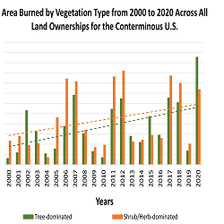
Wildfires burned more area on non-forested lands than forested lands over the past 20 years. This was true for all land ownerships in CONUS and the western US. Burned area increased over the 20-year time period for both non-forest and forest. Across CONUS, annual area burned was higher on non-forest than forests for 14 of the past 21 years (Fig. 1), and total area burned was almost 3,000,000 ha more in non-forest than in forest. For the western US, total burned area was almost 1,500,000 ha more in non-forest than in forest. From a federal agency perspective, approximately 74% of the burned area on Department of the Interior (DOI) lands occurred in non-forest and 78% of the burned area on US Forest Service (FS) lands occurred in the forest.
View article.
We use a unique dataset derived from contemporary (∼2016) remeasurement of 440 historical quadrats (∼4m2) in the central Sierra Nevada, California, in which overstory trees, tree regeneration, and microsite conditions were measured and mapped both before and after logging in 1928–1929. Pine relative abundance changed little with logging and declined to 5% of the contemporary regeneration layer. In contrast, the relative abundance of incense-cedar regeneration (32%) already outpaced its representation in the overstory (17% by basal area) before logging and proceeded to dominate the contemporary understory (49%). We did not find strong evidence for the positive influence of gaps on pine regeneration in any time period. However, across species, post-logging skid trails were positively associated with regeneration and woody debris was negatively associated with regeneration in at least one time period. We discovered that the occurrence of advance regeneration (regeneration that preceded and survived logging) best predicted new contemporary trees across all species. For shade-tolerant species, post-logging regeneration that established up to ten years after logging was also associated with new contemporary trees. In contrast, the few pine that transitioned into the contemporary canopy during the study period all established prior to logging. Our work provides evidence that low pine abundance in the regeneration layer as early as 1928 contributed to low rates of pine in the overstory in 2016, showcasing that the decline of pine likely began before logging and official federal fire suppression policies. We suggest that fire exclusion before logging perpetuated shifts towards shade-tolerant and fire-intolerant species in the regeneration layer that were early and lasting.

Webinar join link.
Presenter: Douglas J. Shinneman, Research Ecologist, USGS Forest and Rangeland Ecosystem Science Center
Description: Accurately assessing recent and historical wildfire activity is critical for numerous agencies who manage fire-prone landscapes. The Wildland Fire Trends Tool (WFTT) is a data visualization and analysis tool that calculates and displays wildfire trends and patterns for the western U.S. based on user-selected regions of interest, time periods, and ecosystem types. For instance, users can determine whether the area burned by wildfire is increasing or decreasing over time for a specific ecoregion or for land ownership types of interest. The tool is available via a web application and generates a variety of maps, graphs, and tabular data that provide useful information for fire science and management objectives, as well as for the interested public.
Human population growth and accessibility from cities shape rangeland condition in the American West
View article.
Human population growth contributes to the decline of sagebrush-steppe rangelands. More accessible rangelands from population centers have higher quality. Open space preservation provides opportunities for rangeland conservation in cities. Coordinated conservation strategies are necessary to protect rangeland ecosystems.
View article.
This study documented a 246% rise in West-wide structure loss from wildfires between 1999–2009 and 2010–2020, driven strongly by events in 2017, 2018, and 2020. Increased structure loss was not due to increased area burned alone. Wildfires became significantly more destructive, with a 160% higher structure-loss rate (loss/kha burned) over the past decade. Structure loss was driven primarily by wildfires from unplanned human-related ignitions (e.g. backyard burning, power lines, etc.), which accounted for 76% of all structure loss and resulted in 10 times more structures destroyed per unit area burned compared with lightning-ignited fires. Annual structure loss was well explained by area burned from human-related ignitions, while decadal structure loss was explained by state-level structure abundance in flammable vegetation. Both predictors increased over recent decades and likely interacted with increased fuel aridity to drive structure-loss trends.