Post-fire Environment & Management

Webinar recording.
We reengineer and rebuild after wildfire through a range of treatments, trying to match our built infrastructure to new, amplified patterns of runoff. A national wildfire practitioner speaks to how leaders and policy makers are increasingly recognizing the need to manage the built environment to accommodate these changes, and an environmental engineer shares a powerful story of transformation in the face of repeated wildfire events.

View article.
Forest recovery was generally associated with cooler, mesic sites in proximity to forested refugia; shifts toward scrub and grassland types were most common in warmer, dryer locations distant from forested refugia. Under future climate scenarios, models project decreases in postfire forest recovery and increases in nonforest vegetation. However, forest to nonforest conversion was partially offset under a scenario of reduced burn severity and increased retention of forested refugia, highlighting important management opportunities. Burning trends in the southwestern United States suggest that postfire vegetation will occupy a growing landscape fraction, compelling renewed management focus on these areas and paradigm shifts that accommodate ecological change. I illustrate how management decisions around resisting, accepting, or directing change could be informed by an understanding of processes and patterns of postfire community variation and likely future trajectories.
View article.
Scaling up climate-adaptation in wildfire-prone watersheds requires innovative partnerships and funding. Water utilities are one stakeholder group that could play a role in these efforts. The overarching purpose of this study was to understand water utility engagement in wildfire mitigation efforts in the western United States. We conducted an online survey of water utilities in nine states and received 173 useable responses. While most (68%) respondents were concerned or very concerned about future wildfire events and the impact of wildfire on their operations, only 39% perceived their organization as responsible for mitigating wildfire risk. Federal land ownership decreased feeling responsible for wildfire mitigation, while concern for and information on wildfire increased feeling responsible for mitigation. The perception of response efficacy of mitigation actions for the 68 water utilities engaged in wildfire risk mitigation activities was very high, with most agreeing that mitigation actions are effective. Self-efficacy to implement mitigation actions, however, was mixed, with most utilities wanting more information on wildfire risk and impacts to watershed services. The most reported wildfire mitigation actions were forest thinning and stream restoration. Water utilities engaging in these actions typically partnered with government agencies or other water utilities to complete the work and funded these activities through water user fees and grants. Our findings suggest that water utility engagement in wildfire mitigation for water security could be increased through providing more assessments of wildfire risk to water utilities and through more outreach and engagement with water utilities operating on federal lands.
View recording (1:03:34).
Wildfire is part of the landscape in the Southwest. It can be a threat to lives and property, but it is also crucial to maintaining healthy ecosystems. Please join the Southwest Fire Science Consortium for a webinar reviewing the top 8 biggest fires in the region in 2023 and looking ahead toward fire conditions for summer 2024. Zander Evans and Mike Lynch of the Forest Stewards Guild place the 2023 Southwest fire season within the context of the last 10 years, pointing out trends and outliers in the timing, management costs, vegetation, and burn severity for each of nine fires larger than 10,000 acres. Rich Naden discusses the Region’s fire season outlook and 2024 summer weather forecast. This webinar sets the stage for the publication of “2023 Wildfire Season: An Overview Southwestern US”, the eleventh in a series of annual overviews available from the Southwest Fire Science Consortium and the Ecological Restoration Institute.
Presenters: Dr. Zander Evans, Executive Director, and Mike Lynch, Midwest Region Director with the Forest Stewards Guild; Richard Naden, Fire Weather Meteorologist with the National Park Service
View article.
Climate change is altering fire regimes and post-fire conditions, contributing to relatively rapid transformation of landscapes across the western US. Studies are increasingly documenting post-fire vegetation transitions, particularly from forest to non-forest conditions or from sagebrush to invasive annual grasses. The prevalence of climate-driven, post-fire vegetation transitions is likely to increase in the future with major impacts on social–ecological systems. However, research and management communities have only recently focused attention on this emerging climate risk, and many knowledge gaps remain. We identify three key needs for advancing the management of post-fire vegetation transitions, including centering Indigenous communities in collaborative management of fire-prone ecosystems, developing decision-relevant science to inform pre- and post-fire management, and supporting adaptive management through improved monitoring and information-sharing across geographic and organizational boundaries. We highlight promising examples that are helping to transform the perception and management of post-fire vegetation transitions.

View storymap.
Public and private landowners have come together to lay out a path for recovery. Major partners in the region are uniting behind a groundbreaking cross-jurisdictional approach to restore resilient forests in Oregon’s Klamath and Lake counties. The resulting strategy has become a national blueprint for post-wildfire recovery.
Webinar recording.
The Santa Clara Canyon in northern New Mexico suffered near total scorching during the Las Conchas Wildfire, a burn which drastically changed the environment and sediment stability of the canyon. After the fire, a 1% chance rain event exhibited a 400% increase in peak flow conditions when compared to pre-fire conditions due to extreme vegetation loss and subsequent soil instability. Since 2011, the Santa Clara Pueblo, Forestry Department has worked with partners to reduce flood hazard in the Pueblo by implementing Engineering with Nature principles: levee improvements, post-fire debris removal, integrating fish passage into the dams, contour felling on steep slopes, and constructing log and boulder structures to stabilize drainages and mitigate sediment transport and deposition.
Managing wildfire recovery efforts by applying Engineering With Nature-Natural and Nature-Based Features (EWN-NNBF) principles has the potential to provide a wide range of Flood Risk Management (FRM) benefits to rural and urban settings while increasing co-benefits for the entire watershed. Co-benefits include economic, social, archeological, aesthetic, recreational and biological functioning habitat enhancements. In this webinar, the presenter will discuss experiences gained and lessons learned that can be transferred to other areas within the Western US that experience wildfires and require FRM guidance on wildfire recovery methods.
View article.
The Great Basin of the western United States is experiencing dramatic increases in wildfire and Bromus species invasion that potentially accelerate wind erosion and plant community change. We used a wind erosion model parameterized for rangelands and standard ecological monitoring data sets collected at 10,779 locations from 2011 to 2019 to characterize potential wind erosion in the Great Basin, assess relationships between factors affecting wind erosion, and quantify effects of wildfire and invasive Bromus species on aeolian horizontal sediment flux, Q. There were 403 monitoring plots (∼3.7% of plots) with Q > 100 g m⁻¹ d⁻¹. Median values for the highest Q category (>100) ranged from 196.5 to 308.5 g m⁻¹ d⁻¹. Locations with Q > 100 g m⁻¹ d⁻¹ were associated with dry, low elevation areas of the Great Basin with low perennial grass and perennial forb cover, and with large bare gaps between plants. Areas with high perennial grass, perennial forb, and shrub cover had small Q (≤10 g m⁻¹ d⁻¹). Substantial wind erosion was predicted in areas that have experienced wildfires, but areas with multiple wildfires had a lower predicted probability of Q particularly as invasive Bromus species cover increased. Modeled Q was up to two orders of magnitude higher post‐wildfire (median 44.2 g m⁻¹ d⁻¹) than in intact or annual grass‐invaded regions of the Great Basin (median 0.4 g m⁻¹ d⁻¹). Our results reveal the complex interplay among plant community composition, wildfire, and the amount of bare ground controlling wind erosion on Great Basin rangelands.
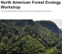
Workshop website.
The 14th North American Forest Ecology Workshop (NAFEW) will take place June 24 – 27, 2024 in Asheville, NC
The format of the meeting will be different from past years, as we will kick off the meeting with all day field trips on Monday followed by a plenary talk in the evening. Sessions will be offered all day Tuesday, half day Wednesday, and all day Thursday. Local field trips will be offered Wednesday afternoon and workshops will occur throughout the week. A banquet is planned for Tuesday evening.