Fact Sheet / Brief
View brief.
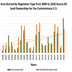
Wildfires burned more area on non-forested lands than forested lands over the past 20 years. This was true for all land ownerships in CONUS and the western US. Burned area increased over the 20-year time period for both non-forest and forest. Across CONUS, annual area burned was higher on non-forest than forests for 14 of the past 21 years (Fig. 1), and total area burned was almost 3,000,000 ha more in non-forest than in forest. For the western US, total burned area was almost 1,500,000 ha more in non-forest than in forest. From a federal agency perspective, approximately 74% of the burned area on Department of the Interior (DOI) lands occurred in non-forest and 78% of the burned area on US Forest Service (FS) lands occurred in the forest.
View factsheet.
Across the globe, a network of national parks, nature reserves, and wilderness areas provides necessary refuge for the world’s biodiversity, and yet these spaces are themselves susceptible to the effects of climate change. As the planet warms, species may need to adjust their ranges, moving among protected areas over time to maintain similar climate conditions.
View factsheet.
Scientists identified the most pollinator-friendly plants to include in seed mixes for use in restoration projects in the Northern Rockies.
View factsheet.
Scientists developed a new tool to help wildland fire personel know if a safety zone is large enough to protect firefighters.
View brief.
Past practices, such as fire suppression, have created densely packed forests with an overabundance of woody vegetation. Live or dead, this vegetation can fuel severe wildfire. Overcrowded growing conditions also prevent trees and other plants from obtaining sufficient nutrients, light, or water to bounce back and remain healthy following a stressful event. The warming climate further stresses vegetation and can foster tinderbox conditions on the landscape, especially under widespread persistent drought.
View brief.
The Wildfire Crisis Strategy calls for ramping up forest treatments on Federal, State, Tribal, and private lands well above current levels. Public and stakeholder engagement, consultation, and collaboration are critical to successful implementation of the strategy. Best available science can inform how to improve the way we engage with communities and help us collectively determine the right treatment locations and tools.
View the infographic.
Nonnative species can be introduced or exacerbated by fire and fuels treatments. This resource describes how this can happen and what can be done to minimize the occurrence of nonnative species on burned sites or following fuels management.
View factsheet.
Fire can be a useful tool for promoting migrations of shade-intolerant wind dispersed species such as aspen. Aspen successfully established in burned areas far from seed sources, so managers may choose to focus attention on other species in postburn reforestation.
View factsheet.
Assessing the geomorphic sensitivity of streams and the ecological resilience of riparian ecosystems provides the basis for understanding how they have responded to disturbances and management actions and how they are expected to respond in the future.
A collaborative group of managers and scientists led by Jeanne Chambers, research ecologist and senior scientist (emeritus) with the USDA Forest Service Rocky Mountain Research Station, and geomorphologist Jerry Miller, a professor of environmental science at Western Carolina University, developed a multiscale approach to help land managers rapidly assess watersheds and categorize them based on resilience and sensitivity to disturbance. The project was built on the long-term work of Chambers and her collaborators on Great Basin riparian ecosystems.
View factsheet.
2020 was a record year for wildfires in recent history, though the area burned was close to estimates of pre-suppression burning. We should expect more of these types of fire seasons in the future. Much of the burning was destructive rather than restorative and impacts to humans were severe.


