Fire Regimes

View article.
Although fire is a fundamental ecological process in western North American forests, climate warming and accumulating forest fuels due to fire suppression have led to wildfires that burn at high severity across larger fractions of their footprint than were historically typical. These trends have spiked upwards in recent years and are particularly pronounced in the Sierra Nevada–Southern Cascades ecoregion of California, USA, and neighboring states. We assessed annual area burned (AAB) and percentage of area burned at high and low-to-moderate severity for seven major forest types in this region from 1984 to 2020. We compared values for this period against estimates for the pre-Euro-American settlement (EAS) period prior to 1850 and against a previous study of trends from 1984 to 2009.
View article.
Here, we examine how the ventenata invasion alters simulated fire across forest-mosaic landscapes of the 7 million ha Blue Mountains Ecoregion using the large fire simulator (FSim) with custom fuel landscapes: present-day invaded versus historic uninvaded. Invasion increased simulated mean fire size, burn probability, and flame lengths throughout the ecoregion, and the strength of these impacts varied by location and scale. Changes at the ecoregion scale were relatively modest given that fine fuels increased in only 2.8% of the ecoregion where ventenata invaded historically fuel-limited vegetation types. However, strong localized changes were simulated
within invaded patches (primarily dwarf-shrublands) and where invasion facilitated fire spread into nearby forests.
View story map.
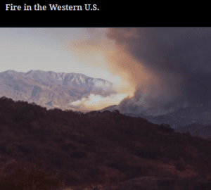
But over the past few decades, wildfires have worsened by almost every metric. It’s impossible to ignore this new consequence of environmental change. Fires are getting larger, more severe, more destructive and dangerous, and eliminating entire patches of forests, grasslands, and shrublands.
The combination of changing climate, extreme weather, land use, aggressive fire suppression policies, and wildland urban interface expansion have contributed to altered fire behavior regimes. And all of these past and current factors are converging in a big way in the western U.S. Today’s megafires pose an increasing threat to human health, infrastructure, natural resources, and ecosystem resilience.

This study found that wildfires burned more area of non-forest lands than forest lands at the scale of the conterminous and western U.S. and the Department of Interior (DOI). In an agency comparison, 74% of DOI burned area occurred on non-forest lands and 78% of U.S. Forest Service burned area occurred on forested lands. Landscape metrics revealed key differences between forest and non-forest fire patterns and trends in total burned area, burned patch size, distribution, and aggregation over time across the western U.S. Opposite fire patterns emerged between non-forest and forest burns when analyzed at the scale of federal agency jurisdictions. In addition, a fire regime departure analysis comparing current large fire probability with historic fire trends identified certain vegetation types and locations experiencing more fire than historically. These patterns were especially pronounced for cold desert shrublands, such as sagebrush where increases in annual area burned, and fire frequency, size, and juxtaposition have resulted in substantial losses over a twenty-year period.
View article.
Human-dominated pyromes (85% mean anthropogenic ignitions), with moderate fire size, area burned, and intensity, covered 59% of CONUS, primarily in the East and East Central. Physically dominated pyromes (47% mean anthropogenic ignitions) characterized by relatively large (average 439 mean annual ha per 50 km pixel) and intense (average 75 mean annual megawatts/pixel) fires occurred in 14% of CONUS, primarily in the West and West Central. The percent of anthropogenic ignitions increased over time in all pyromes (0.5–1.7% annually). Higher fire frequency was related to smaller events and lower FRP, and these relationships were moderated by vegetation, climate, and ignition type. Notably, a spatial mismatch between our derived modern pyromes and both ecoregions and historical fire regimes suggests other major drivers for modern U.S. fire patterns than vegetation-based classification systems. This effort to delineate modern U.S. pyromes based on fire observations provides a national-scale framework of contemporary fire regions and may help elucidate patterns of change in an uncertain future.

Access tool.
The Wildland Fire Trends Tool (WFTT) is a data visualization and analysis tool that calculates and displays wildfire trends and patterns for the western U.S. based on user-defined regions of interest, time periods, and ecosystem types. Users can use the tool to easily generate a variety of maps, graphs, and tabular data products that are informative for all levels of expertise. The WFTT provides information that can be used for a wide range of purposes, from helping to set agency fire management objectives to providing useful information to scientists, interested public, and the media.
View article.
Reports from the early 1900s, along with paleo- and dendro-ecological records, indicate similar and potentially even larger wildfires over the past millennium, many of which shared similar seasonality (late August/early September), weather conditions, and even geographic locations. Consistent with the largest historical fires, strong east winds and anomalously dry conditions drove the rapid spread of high-severity wildfire in 2020. We found minimal difference in burn severity among stand structural types related to previous management in the 2020 fires. Adaptation strategies for similar fires in the future could benefit by focusing on ignition prevention, fire suppression, and community preparedness, as opposed to fuel treatments that are unlikely to mitigate fire severity during extreme weather. While scientific uncertainties remain regarding the nature of infrequent, high-severity fires in westside forests, particularly under climate change, adapting to their future occurrence will require different strategies than those in interior, dry forests.
View article.
This study used a coupled ecohydrologic and fire regime model to examine how climate change and CO2 scenarios influence fire regimes. In this semiarid watershed, we found an increase in burned area and burn probability in the mid-21st century (2040s) as the CO2 fertilization effect on vegetation productivity outstripped the effects of climate change-induced fuel decreases, resulting in greater fuel loading. However, by the late-21st century (2070s), climatic warming dominated over CO2 fertilization, thus reducing fuel loading and burned area. Fire regimes were shown to shift from flammability- to fuel-limited or become increasingly fuel-limited in response to climate change. We identified a metric to identify when fire regimes shift from flammability- to fuel-limited: the ratio of the change in fuel loading to the change in its aridity. The threshold value for which this metric indicates a flammability versus fuel-limited regime differed between grasses and woody species but remained stationary over time. Our results suggest that identifying these thresholds in other systems requires narrowing uncertainty in exogenous drivers, such as future precipitation patterns and CO2 effects on vegetation.
2020 California fire season: A year like no other, a return to the past, or harbinger of the future?
View article.
The 2020 fires were part of an accelerating decades-long trend of increasing burned area, fire size, fire severity and socio-ecological costs in California. In fire-prone forests, the management emphasis on reducing burned area should be replaced by a focus on reducing the severity of burning and restoring key ecosystem functions after fire. There have been positive developments in California vis-à-vis collaborative action and increased pace and scale of fuel management and pre- and postfire restoration, but the warming climate and other factors are rapidly constraining our options.